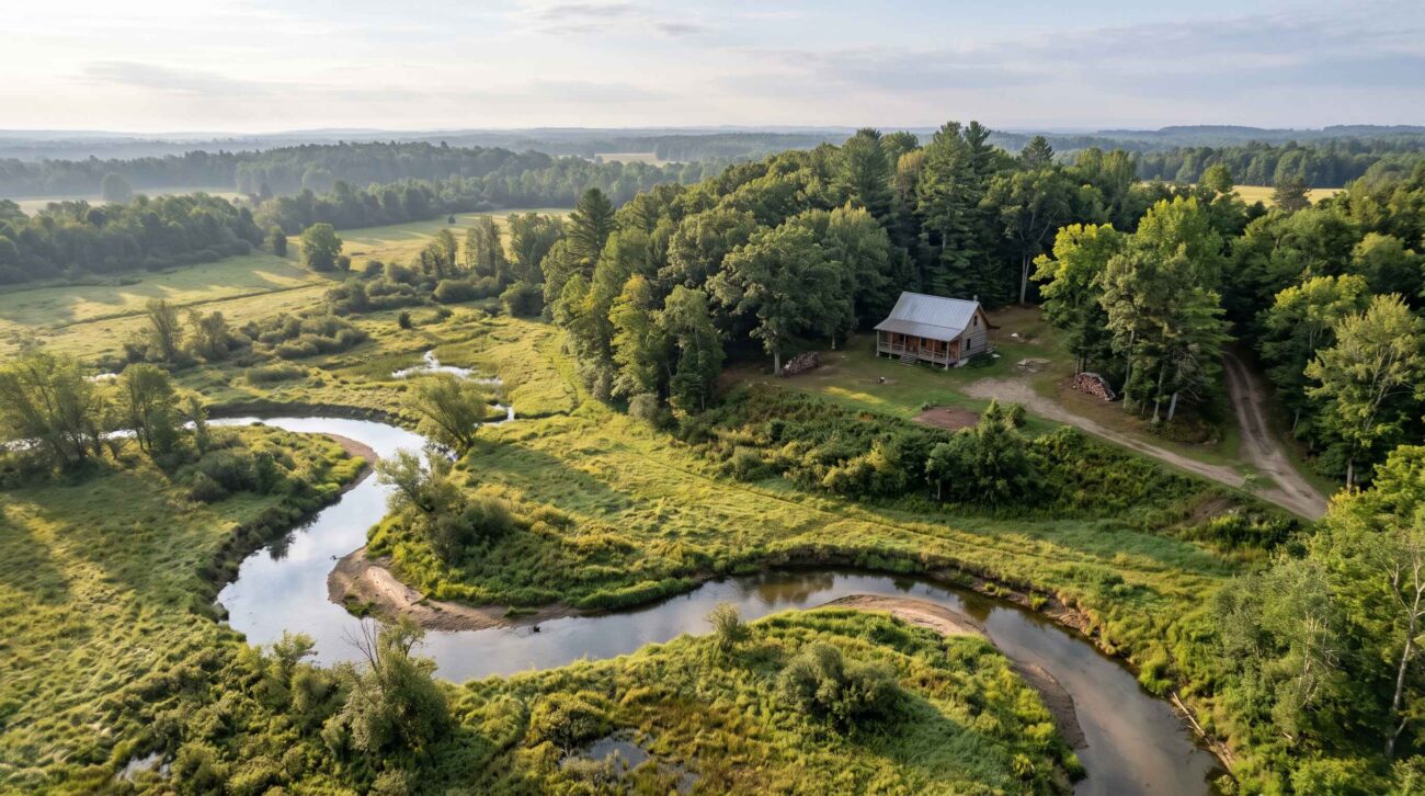
A creek running through a wooded property can be one of its most attractive features. River frontage, a private pond, or a low meadow may make inexpensive rural land seem ideal for a cabin, homestead, or weekend retreat.
But water can also create problems that are difficult to recognize from listing photographs.
A property may contain land that floods during heavy rain, a driveway that becomes impassable, or a low-lying building site that requires additional engineering and permits.
Before buying rural land in the United States, it is important to understand how to check flood risk, what government maps can tell you, and which questions still require local research or professional evaluation.
This guide explains a practical, step-by-step process.
1. Understand What a Flood Map Actually Shows
The Federal Emergency Management Agency (FEMA) publishes flood hazard maps used for floodplain management and the National Flood Insurance Program.
These maps identify areas with different levels of mapped flood hazard.
The official starting point is the FEMA Flood Map Service Center.
However, a flood map does not guarantee that every area outside a designated high-risk zone is safe from flooding.
Local drainage problems, intense rainfall, blocked culverts, and smaller streams may create risks that are not fully represented.
That distinction matters for rural buyers, particularly when a property includes a creek, valley, low field, or seasonal drainage channel.
2. How to Check a Property Using FEMA’s Flood Map Service Center
You can begin your research without paying for a private flood-risk report.
Step 1: Open the official FEMA website
Visit: https://msc.fema.gov/portal/home
Use the address search to locate the property.
If the property has no assigned street address, search using a nearby location or geographic coordinates where supported.
Step 2: Find the relevant flood map
Review the available Flood Insurance Rate Map (FIRM) or other official flood hazard products.
Make sure the map corresponds to the correct location.
For a large rural parcel, the house or driveway may be in a different area from the remainder of the land.
Step 3: Identify the flood zone
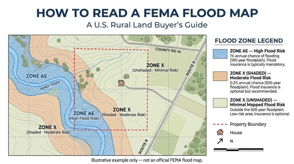
Common FEMA designations include:
| Flood Zone | General Meaning |
|---|---|
| A | Special Flood Hazard Area with a 1% annual-chance flood hazard; detailed elevations may not be provided |
| AE | Special Flood Hazard Area with a 1% annual-chance flood hazard and established base flood elevations |
| X (shaded) | Moderate flood hazard, including certain areas with a 0.2% annual-chance flood hazard |
| X (unshaded) | Areas generally mapped as having minimal flood hazard |
| Floodway | An area associated with a river or stream where development may face particularly strict restrictions |
A 1% annual-chance flood does not mean flooding happens only once every 100 years. It means the modeled event has a 1% probability of occurring in any given year.
Flooding can occur more than once within a short period.
Step 4: Save the map and its details
Record the map panel, effective date, flood-zone designation, and any applicable map changes.
These details help you communicate with the county floodplain administrator, insurance provider, and lender.
Step 5: Check the entire parcel
Do not stop after identifying the flood zone at the road or mailbox.
If you are considering a cabin or new house, examine the intended building site, driveway, septic area, and access route.
A property can contain both higher-risk and lower-risk areas.
Important: FEMA’s mapping tools are a screening resource. They do not replace a boundary survey, site-specific elevation data, or professional floodplain determination.
3. Why a Property Outside a High-Risk Flood Zone Can Still Flood
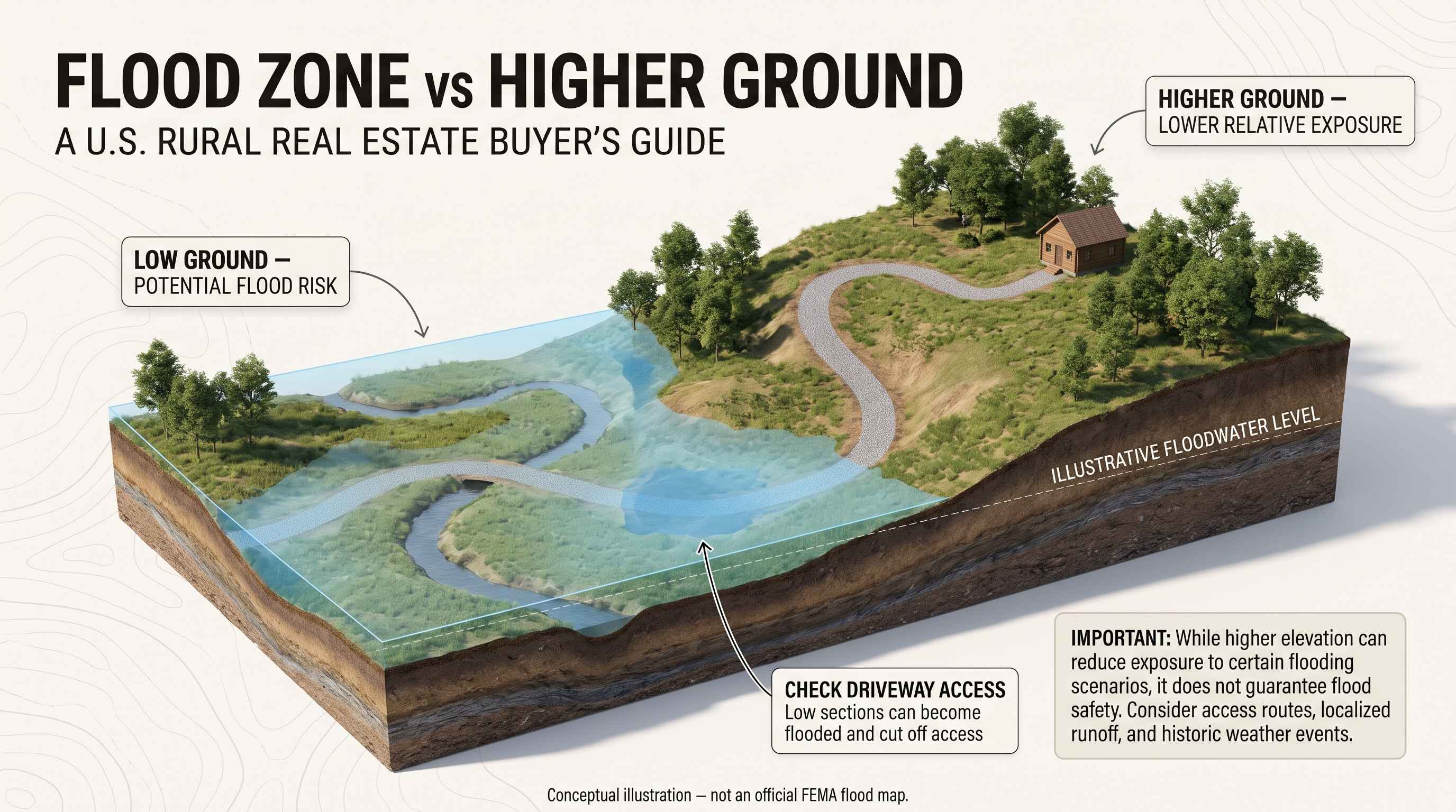
One of the most common mistakes buyers make is assuming that a location outside a mapped Special Flood Hazard Area has no flood exposure.
Consider a hypothetical 20-acre property with a small creek running through the center.
The FEMA map might show the creek corridor as a higher-risk area while other parts of the parcel appear outside the mapped floodplain.
But the buyer still needs to consider:
- Whether the driveway crosses the creek.
- Whether heavy rainfall causes runoff to collect near the cabin.
- Whether a culvert becomes blocked.
- Whether the ground slopes toward the house.
- Whether the proposed septic area is seasonally saturated.
- Whether the road is accessible during storms.
These questions involve local drainage and property conditions that a national map cannot fully resolve.
The U.S. Geological Survey provides additional flood information and links to relevant mapping resources through its flood map guidance.
4. Check Whether Wetlands Are Present
Wetlands and floodplains are related concepts, but they are not interchangeable.
A property may contain wetlands without being entirely within a FEMA high-risk flood zone.
Wetlands can also affect where construction, filling, grading, or drainage modifications may be permitted.
The U.S. Fish and Wildlife Service provides a free National Wetlands Inventory Mapper.
How to use it
- Open the Wetlands Mapper.
- Locate the property or surrounding area.
- Examine the mapped wetland features.
- Compare those features with the proposed building site and access road.
- Contact the appropriate regulatory agencies if construction could affect wetlands or waters.
The agency cautions that its inventory does not establish the legal boundaries of regulated wetlands.
A map showing no wetlands is not proof that regulated wetlands are absent.
If a project may affect waters or wetlands, seek guidance from the relevant U.S. Army Corps of Engineers regulatory office and state or local authorities.
5. Use USDA Soil Data to Identify Potential Drainage Concerns
Soil conditions influence how water moves through a property.
Some soils drain relatively quickly, while others remain saturated for extended periods.
The USDA Web Soil Survey provides official soil information that can help buyers investigate these conditions.
What to examine
After identifying an area of interest, review available soil interpretations for:
- Drainage class.
- Seasonal wetness.
- Depth to a seasonal water table.
- Flooding or ponding frequency.
- Limitations for buildings or onsite wastewater systems.
For example, a field that appears dry during summer may still have seasonal saturation that affects septic design or construction.
Soil survey data is useful for preliminary planning, but USDA notes that onsite investigation is needed for certain engineering and land-use decisions.
A qualified local professional must determine whether a particular building or septic location is suitable.
For more information, see our Rural Property Utilities Checklist.
6. Investigate Flood History Beyond the Maps
Government maps are an important starting point, but buyers should also research what has actually happened in the area.
Useful questions include:
- Has the property experienced flooding or standing water?
- Has the driveway ever washed out?
- Has the basement or crawl space flooded?
- Have nearby bridges or roads closed during storms?
- Have drainage channels or culverts been repaired?
- Are there previous insurance claims or documented flood damage?
Ask the seller for relevant disclosures and supporting records.
You can also contact local floodplain management or emergency management offices for information about known flooding issues.
Historical aerial photographs, local government records, and documented flood events may provide additional context.
A lack of documented past flooding does not establish that future flooding is impossible.
7. Pay Special Attention to Creek and River Access
Creek-front properties can be appealing for recreation and scenery.
However, a creek creates additional questions about access, erosion, and the usable portion of the parcel.
Imagine a rural property where the cabin is on elevated ground, but the only driveway crosses a low-water crossing.
Even if the cabin itself remains dry, a flood could temporarily prevent the owner from entering or leaving.
Before purchasing creek-front land, verify:
- Whether access crosses a stream or flood-prone low area.
- Whether bridges and culverts are legally permitted and maintained.
- Whether the banks show signs of erosion.
- Whether the property has a recorded, legally enforceable access route.
- Whether the intended building site is separated from flood-prone land.
- Whether local rules restrict construction near the waterway.
If the property depends on a private road or easement, also review our guide to legal road access when buying rural land.
8. Understand Flood Insurance Before Buying
Flood insurance requirements can depend on the property’s mapped location, the lender, and the type of mortgage.
For buildings in certain high-risk flood areas, federal law may require flood insurance when financing is provided through a federally regulated or insured lender.
However, buyers outside those areas may still benefit from evaluating flood coverage.
Standard homeowners insurance policies generally do not cover flood damage.
Before making an offer, ask an insurance professional to explain:
- Whether flood insurance is required.
- Whether coverage is available through the National Flood Insurance Program or private insurers.
- The estimated premium and deductible.
- The coverage limits and exclusions.
- Whether additional documentation or elevation information is needed.
Insurance availability and cost should be considered alongside the purchase price, not after closing.
For official flood insurance information, visit FloodSmart.gov.
9. Check Building Restrictions Before Planning a Cabin
A low-cost rural parcel may look spacious on paper while offering only a limited area suitable for construction.
Floodplain regulations, wetlands, septic requirements, setbacks, and local zoning can all affect development plans.
Before purchasing land for a cabin or house, contact the local building or planning office and ask:
- Is the proposed building location inside a regulated floodplain?
- Is a floodplain development permit required?
- Are minimum building elevations or other flood-resistant construction measures required?
- Are there restrictions on grading or filling?
- Can the proposed driveway or crossing be approved?
- Can the parcel support an approved wastewater system?
- Are there any additional state or local waterway restrictions?
Obtain written guidance whenever possible.
For related research, read How to Check Zoning Before Buying Rural Land and Can You Build a House on Cheap Rural Land?.
10. A Practical Flood-Risk Research Example
Consider two hypothetical 15-acre rural properties listed at similar prices.
| Question | Property A | Property B |
|---|---|---|
| Water feature | Creek along rear boundary | Creek crossing the driveway |
| Proposed cabin site | Elevated area | Low-lying meadow |
| Driveway | Higher ground | Stream crossing |
| FEMA map | Part of parcel in mapped floodplain | Part of parcel in mapped floodplain |
| Additional research | Confirm buildable area and septic location | Investigate crossing, drainage, elevation, and access |
| Main concern | Usable acreage | Safe access and construction feasibility |
Both properties may look attractive in photographs.
But the second property presents a more complicated set of questions because the access route and proposed building site may be exposed.
This example illustrates why the total acreage and listing price are not enough to evaluate a rural property.
The location of the usable land matters.
These are hypothetical scenarios, not assessments of actual listings.
11. Flood-Risk Checklist Before Making an Offer
Use this checklist during your research.
- Locate the parcel on the official FEMA flood map.
- Record the relevant flood-zone designation and map date.
- Check the proposed building site, not just the road address.
- Examine the driveway and any creek crossings.
- Review the USFWS Wetlands Mapper.
- Review USDA soil drainage and flooding information.
- Ask the seller about previous water damage or flooding.
- Contact the local floodplain administrator.
- Verify septic and construction requirements.
- Obtain a preliminary flood insurance quote.
- Investigate local road closures and historical flooding.
- Arrange professional inspections or surveys when needed.
If major uncertainties remain, discuss appropriate inspection and due-diligence contingencies with your real estate and legal professionals before signing a purchase agreement.
Frequently Asked Questions
Can rural land flood even if it is not in a FEMA high-risk flood zone?
Yes. FEMA maps do not capture every possible flooding scenario, particularly some localized drainage and heavy-rainfall events.
Does a creek automatically make land unsuitable for building?
No. Suitability depends on the creek’s location, floodplain boundaries, terrain, soil conditions, applicable regulations, and the proposed construction site.
Are wetlands the same as flood zones?
No. Wetlands and FEMA flood hazard areas represent different environmental and regulatory concepts. A parcel may contain one, both, or neither.
Can I build a cabin in a floodplain?
Construction may be possible in some locations, subject to floodplain regulations, permits, elevation requirements, and other restrictions. Local authorities must confirm what is allowed.
Is flood insurance necessary outside a high-risk zone?
It may not be legally required by a lender, but flooding can still occur. Buyers should evaluate their actual exposure and available coverage.
Final Thoughts
Flood risk is one of the most important issues to investigate before purchasing rural land, especially when a property includes a creek, river, pond, or low-lying area.
The goal is not to avoid every property near water. It is to understand where the risks are, how they affect the usable land, and whether they can be managed within the buyer’s plans and budget.
Start with FEMA maps, then examine wetlands, soil conditions, local flood history, access, and construction restrictions.
A property with beautiful water features can still be a good purchase—but only when its limitations are understood before closing.
Official Resources
- FEMA Flood Map Service Center — Official flood hazard mapping.
- USGS: Where Can I Find Flood Maps? — Flood mapping and related resources.
- U.S. Fish & Wildlife Service: Wetlands Mapper — National wetland inventory.
- USDA NRCS: Web Soil Survey — Soil and land-use information.
- FloodSmart.gov — Flood insurance information.
Editorial disclaimer: This article is for educational purposes only. Flood maps, wetlands inventories, and soil surveys are screening tools and do not replace professional site assessments, official regulatory determinations, surveys, or legal advice. Requirements vary by location. Consult qualified professionals and relevant local authorities before buying or developing land.
