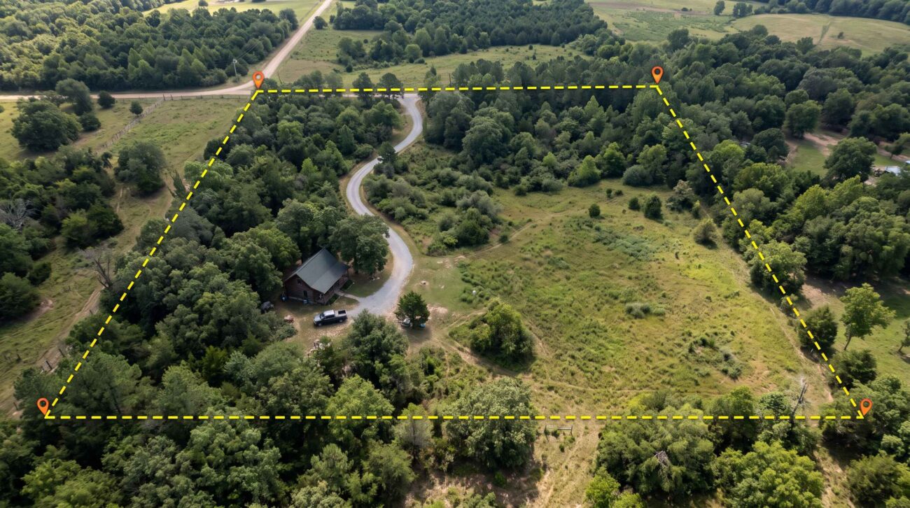
A 40-acre wooded property may look like an excellent opportunity for someone planning a cabin, homestead, or private hunting retreat. The listing photographs show mature trees, open fields, and a quiet gravel road. An online parcel map even displays what appears to be a clearly defined boundary.
But there is one important question: Where does the property legally begin and end?
The answer may not be as simple as following an old fence, a tree line, or the colored outline on a real estate website.
Boundary uncertainty can affect the location of a new cabin, driveway access, fencing, timber harvesting, and even the amount of usable land.
This guide explains how to check property boundaries before buying rural land in the United States, including how to research deeds, county GIS maps, surveys, easements, and possible encroachments.
1. Understand the Difference Between a Parcel Map and a Legal Boundary
Online parcel maps are useful research tools, but they should not be treated as professional boundary surveys.
Many county governments provide Geographic Information System (GIS) maps showing parcels, roads, aerial photographs, and tax information.
These maps help buyers identify the approximate location and configuration of a property.
However, a digital parcel outline may not precisely match the legally established boundary on the ground.
The U.S. Geological Survey also explains that Public Land Survey System lines displayed on its topographic maps are not legally authoritative.
Source: USGS — Are PLSS Lines on US Topo Maps a Legal Record?
What county GIS maps can help you investigate
- Approximate parcel location and shape.
- Parcel identification numbers.
- Reported acreage.
- Nearby roads and neighboring parcels.
- Possible access routes.
- Visible buildings, fences, and land features.
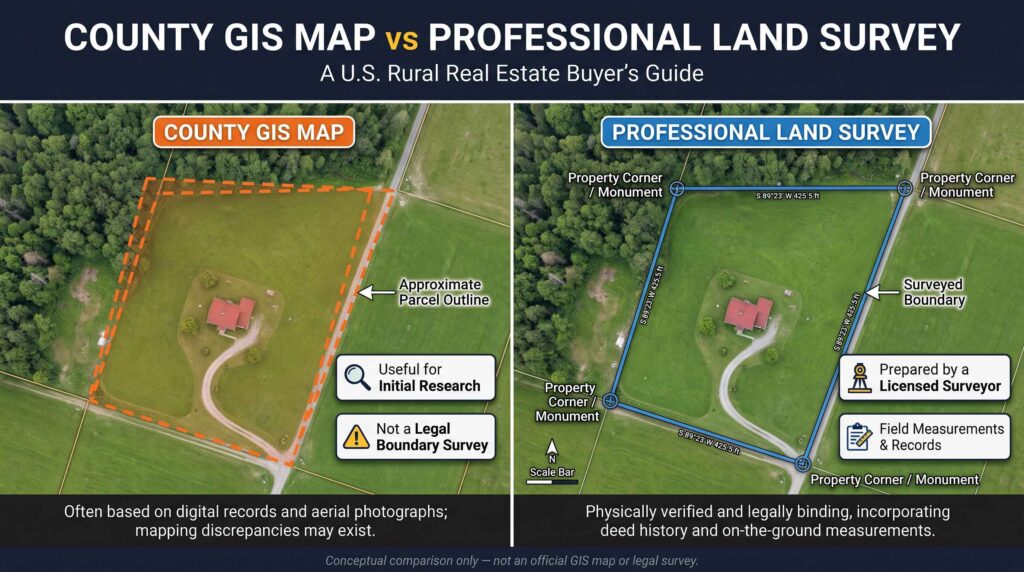
What they cannot reliably establish
A GIS map alone cannot conclusively determine the legal location of a property corner, resolve a disputed boundary, or prove ownership of a narrow strip of land.
EstatePath buyer tip: Use parcel maps to identify questions—not to settle legal boundary disputes.
2. Find the Property’s Parcel Identification Number
One of the most useful starting points is the parcel identification number, sometimes called a parcel ID, tax parcel number, or assessor’s parcel number.
This number helps connect a listing to local government records.
Step-by-step process
- Open the county assessor’s or property appraiser’s official website.
- Search using the property address or owner’s name, where permitted.
- Locate the parcel identification number.
- Check the reported acreage and property description.
- Compare the information with the real estate listing.
County terminology and available records vary by state.
A mismatch does not automatically indicate a problem. However, it should be explained before closing.
For example, a listing might advertise 25 acres while the tax record identifies a slightly different acreage.
Possible explanations include rounding, multiple parcels, historical records, or differences in measurement methods.
Ask the seller, title company, and surveyor to clarify the discrepancy rather than assuming either number is correct.
3. Read the Legal Description in the Deed
A property’s legal description is more important than the marketing address when determining what land is being conveyed.
Legal descriptions may use different systems depending on the location.
Metes and bounds
These descriptions identify boundaries using distances, directions, monuments, and reference points.
They are common in many older rural properties.
Public Land Survey System
In areas using the Public Land Survey System, descriptions may refer to sections, townships, ranges, and subdivisions of those areas.
Lot and block
Some properties are described using a recorded subdivision plat, lot number, and block number.
These systems are not interchangeable, and the wording can be technical.
A licensed land surveyor can interpret the description in relation to recorded documents and physical evidence.
A real estate attorney or title professional can help address legal questions about what interests the seller can convey.
Documents worth requesting
Ask for the current deed, any available prior surveys, recorded subdivision plats, and documents affecting access or easements.
The county recorder or register of deeds is often the starting point for recorded instruments, although office names vary.
4. Understand What a Professional Boundary Survey Does
A professional boundary survey helps establish the location of property boundaries using relevant records, field measurements, monuments, and other evidence.
The work may include locating existing survey markers, examining recorded documents, evaluating physical occupation, and preparing a survey drawing.
The exact scope depends on the jurisdiction, property, and type of survey ordered.
Why this matters for rural buyers
Imagine purchasing 30 wooded acres with plans to build a cabin near the back of the property.
An online map suggests the proposed building site is comfortably inside the parcel.
But a professional survey could reveal that the legal boundary is closer than expected, affecting setbacks or the proposed driveway.
A survey may identify such issues before the buyer invests in construction plans.
The American Land Title Association and National Society of Professional Surveyors maintain standards for ALTA/NSPS Land Title Surveys, which are especially relevant in certain title insurance and commercial real estate transactions.
The 2026 standards took effect on February 23, 2026.
Source: American Land Title Association — Land Survey Standards
Important distinction: An ALTA/NSPS survey is not automatically required for every residential or rural land purchase. Ask a licensed surveyor and title professional which survey product is appropriate for your transaction.
5. Do Not Assume an Existing Fence Marks the Boundary
An old fence can make a property appear clearly defined.
But fences are not always installed directly on legal boundary lines.
A fence might have been placed inside a property for convenience, built before a subdivision, or constructed without a professional survey.
Similarly, a tree line, creek, stone wall, or farm track may not correspond exactly to the legal boundary.
Warning signs to investigate
- A fence that appears to cross the parcel outline.
- A neighbor’s shed or driveway near the apparent boundary.
- An old logging road used by multiple properties.
- A structure that may be too close to a property line.
- A creek that has shifted position over time.
- Conflicting statements from neighboring landowners.
These observations are reasons to investigate, not proof of encroachment.
If a disagreement arises, avoid moving fences or markers without professional and legal guidance.
6. Check for Easements and Access Rights
A property boundary does not tell the entire story about how land can be used.
An easement may allow another person, utility company, or neighboring property owner to use part of the parcel for a defined purpose.
Common examples include:
- Shared driveways.
- Private access roads.
- Utility lines.
- Drainage facilities.
- Pipeline corridors.
A parcel may also benefit from an easement across someone else’s land.
These rights can affect construction plans, privacy, fencing, and access.
For example, a buyer might discover that a private road crossing the property is subject to recorded access rights benefiting neighboring parcels.
That road may not be available for exclusive use.
Request relevant recorded easement documents and have the title company and appropriate professionals explain their effect.
For a detailed guide, read How to Check Legal Road Access Before Buying Rural Land.
7. Investigate Encroachments Before Closing
An encroachment may occur when a structure or improvement extends across a property boundary.
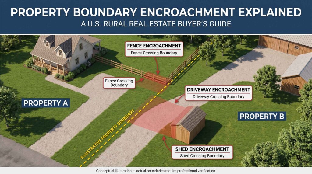
Potential examples include a neighbor’s garage, fence, retaining wall, or driveway.
Not every apparent overlap is a confirmed legal encroachment.
A professional survey and review of the relevant documents may be needed to establish the facts.
Why buyers should care
A boundary issue can complicate future building permits, financing, resale, or the use of a particular area.
Depending on the circumstances and applicable state law, resolving a problem might involve an agreement, easement, boundary adjustment, or legal proceedings.
A buyer should not assume that a long-standing arrangement is automatically legal or that it can be resolved easily.
Ask a real estate attorney about any significant unresolved boundary issue before closing.
8. Verify Acreage Instead of Relying on the Listing
Acreage is one of the main selling points of rural real estate.
However, a stated acreage figure should be treated as information to verify.
One acre equals 43,560 square feet.
That means a 20-acre parcel contains approximately 871,200 square feet.
But knowing the mathematical area does not establish the parcel’s shape, boundary locations, or usable acreage.
Example: Two hypothetical 20-acre properties
| Feature | Property A | Property B |
|---|---|---|
| Advertised acreage | 20 acres | 20 acres |
| Shape | Relatively compact | Long, narrow configuration |
| Access | Direct public road frontage | Private access easement |
| Terrain | Mostly moderate slopes | Steep wooded sections |
| Building possibilities | Multiple potential sites to investigate | Fewer apparent sites |
| Boundary concerns | Existing survey available | No recent survey supplied |
Both parcels contain the same advertised acreage.
However, their practical usefulness could be very different.
A buyer should evaluate the location, configuration, terrain, legal access, setbacks, and environmental limitations—not just the number of acres.
For related due diligence, see How to Buy Rural Land in the USA.
9. Use Aerial Images Carefully
Satellite and aerial photographs can help identify visible features such as roads, fields, buildings, and streams.
They are particularly useful when evaluating large wooded parcels.
But aerial images have limitations.
The photograph may have been taken years earlier, and the parcel overlay may not line up precisely with physical features.
Trees can conceal fences and structures. Shadows, slopes, and seasonal vegetation may make interpretation difficult.
A useful comparison method
Review the listing map, county GIS imagery, recorded survey, and available deed description together.
Mark any differences that need explanation.
For example, if a cabin appears close to a boundary on the aerial image, ask a surveyor to confirm its position before assuming it complies with setback requirements.
Do not use consumer GPS readings or phone mapping apps as a substitute for a professional boundary determination.
10. Check Boundaries Before Planning Construction
A boundary issue becomes particularly important when the buyer intends to build.
Local zoning and building rules may establish setbacks from property lines, roads, streams, and other features.
If the legal boundary is uncertain, the available building area may also be uncertain.
Before designing a cabin or house, verify:
- The legal parcel boundaries.
- Required front, side, and rear setbacks.
- Recorded easements.
- Road access and driveway permits.
- Septic and well separation requirements.
- Floodplain or wetlands restrictions.
- Whether the proposed building site is legally and physically suitable.
Different authorities may regulate different parts of the project.
For additional research, read How to Check Zoning Before Buying Rural Land and How to Check Flood Risk Before Buying Rural Land.
11. How Much Does a Boundary Survey Cost?
There is no single reliable national price for surveying every rural parcel.
The cost depends on factors such as parcel size, terrain, vegetation, accessibility, existing records, the number of corners, and the scope of work.
A remote 80-acre wooded property may require substantially different work from a small residential lot.
Before hiring a surveyor, request a written proposal that explains:
- The type of survey being performed.
- The records and fieldwork included.
- Whether property corners will be located or marked.
- Whether a signed survey drawing will be provided.
- Whether easements and improvements are included.
- The estimated completion schedule.
- The total fee and any potential additional charges.
Obtain estimates from properly licensed surveyors familiar with the property’s state and county.
Do not choose a survey solely because it has the lowest quoted price. The scope of work matters.
12. A Practical Rural Boundary Research Scenario
Consider a hypothetical 40-acre property advertised as having a cabin, creek, and private driveway.
The online map shows a rectangular parcel, but the driveway runs near one edge of the property.
The buyer begins by downloading the county parcel map and requesting the deed.
Next, the buyer asks the title company whether any recorded easements affect the driveway.
A licensed surveyor is then hired to evaluate the property boundaries and the location of the improvements.
The survey identifies the driveway’s position relative to the legal boundary and provides information the buyer can compare with the recorded access documents.
If the driveway crosses another parcel, the buyer must verify the legal right to use it.
If a building is close to a boundary, the buyer can ask the local building office about applicable setbacks and consult the appropriate professionals.
This process is more useful than relying solely on a listing photograph showing a quiet, private-looking road.
This is a fictional educational example, not a description of an actual property.
13. Property Boundary Checklist Before Buying Rural Land
Use this checklist before making a final purchase decision.
- Confirm the correct parcel identification number.
- Compare the advertised acreage with county records.
- Obtain the current recorded deed and legal description.
- Request existing surveys and recorded plats.
- Review county GIS parcel maps.
- Identify potential discrepancies between maps and physical features.
- Ask about shared roads and recorded easements.
- Investigate possible encroachments.
- Confirm access to a public road or legally enforceable access rights.
- Obtain an appropriate survey when needed.
- Check building setbacks and proposed improvement locations.
- Review title commitments, exceptions, and available survey coverage with the title company.
- Resolve significant boundary questions before closing.
If important uncertainties remain, consult your real estate attorney about suitable contract protections and due-diligence contingencies.
Frequently Asked Questions
Can I find my exact property boundaries using Google Maps?
No. Google Maps and similar consumer mapping tools can help locate land, but they do not establish legally authoritative property boundaries.
Are county GIS property lines accurate?
They can be useful for approximate parcel research, but they should not be relied upon as a substitute for a professional survey.
Does a fence prove where the property line is?
Not necessarily. A fence may be inside or outside the legally established boundary. Its location and legal significance may require professional review.
Is a land survey required when buying rural property?
Requirements vary by jurisdiction, lender, title insurer, and transaction. Even when a survey is not mandatory, it may be valuable for identifying boundary concerns before purchase.
Can a property have legal access without direct road frontage?
Yes. Some properties benefit from legally established access easements. However, the existence, scope, and enforceability of those rights must be verified.
Does a title search replace a boundary survey?
No. A title search and a boundary survey serve different purposes. A title search examines recorded interests and other title matters, while a survey evaluates physical boundary and property information. Both may be important.
Final Thoughts
Buying rural land involves more than identifying a beautiful parcel and agreeing on a price.
The legal boundaries determine what land is being purchased, while easements, encroachments, setbacks, and physical conditions influence how that land can be used.
Start with the county’s parcel records and the recorded deed. Compare the available maps, ask about existing surveys, and investigate anything that appears inconsistent.
When the location of a boundary matters to your purchase or construction plans, seek help from a properly licensed land surveyor.
The safest time to investigate a property boundary is before the purchase becomes final—not after a fence, cabin, or driveway has already been built.
Editorial Disclaimer: This article provides general educational information about rural property research in the United States. Boundary determinations, survey requirements, easement rights, and property disputes depend on state law and individual circumstances. EstatePath does not provide surveying, legal, or title insurance services. Consult licensed surveyors, title professionals, local authorities, and qualified attorneys before making decisions about a specific property.
