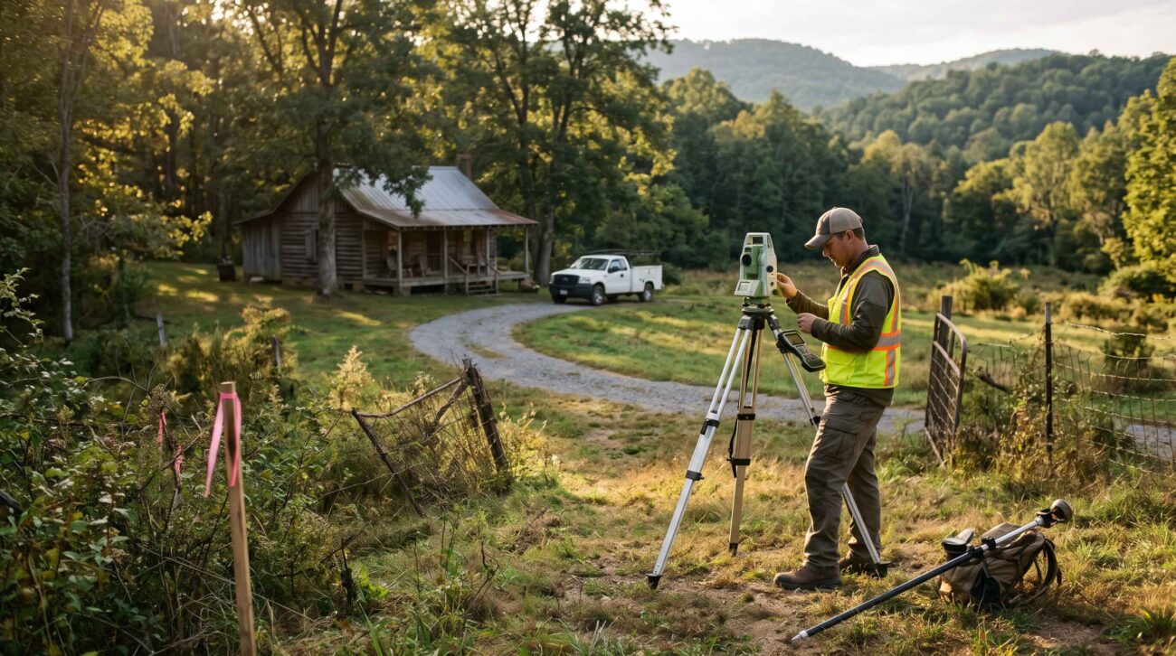
Buying rural land can be exciting, especially when a property offers wooded acreage, mountain views, a creek, or enough space for a future cabin. But before relying on a listing’s advertised acreage or a boundary line shown on an online map, buyers should understand what a professional land survey can establish.
A survey may help identify property boundaries, locate existing monuments, document improvements, and reveal physical conditions that could affect a purchase.
One of the first questions buyers ask is simple: How much does a land survey cost?
There is no single reliable price for every rural property in the United States. Survey costs depend on the location, acreage, terrain, records, boundary complexity, accessibility, and type of work requested.
This guide explains what influences land survey pricing, how to compare survey quotes, when a survey may be appropriate, and what rural buyers should verify before closing.
1. What Is a Land Survey?
A land survey is professional work performed to determine, document, or describe land boundaries and other property features within an agreed scope.
Depending on the type of survey, a licensed professional land surveyor may examine recorded deeds and plats, investigate historical boundary evidence, perform field measurements, locate existing monuments, and prepare a survey drawing.
A survey is different from simply measuring distances on an online map.
A county GIS parcel viewer can be useful for identifying a property and reviewing approximate parcel information. However, the displayed lines should not automatically be treated as legally established boundaries.
Similarly, a listing’s acreage figure may come from tax records, older documents, or other sources that have not been independently verified for the transaction.
Buyer takeaway: Ask what information supports the advertised acreage and whether a recent professional survey is available.
2. How Much Does a Rural Land Survey Cost?
Land survey costs vary substantially across the United States.
A straightforward residential boundary survey may require less work than surveying a remote, heavily wooded parcel with missing monuments and complicated deed descriptions.
A large rural tract may also require additional field crews, research, travel, and time to resolve boundary evidence.
Rather than relying on a national average that may not apply to the property, request written estimates from appropriately licensed local surveyors.
What determines the quoted price?
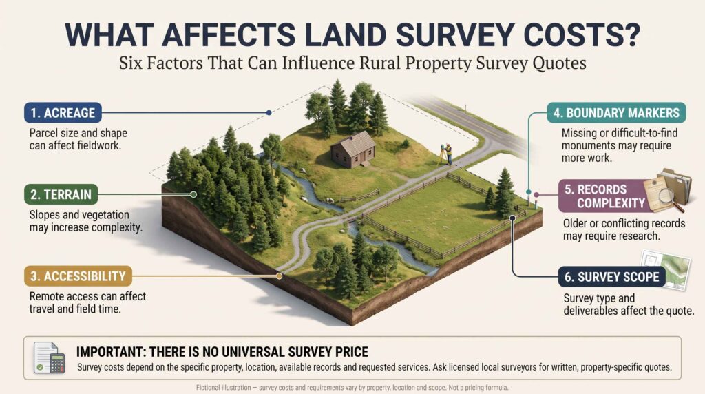
The most important factors often include:
- The number of acres and overall parcel configuration.
- Whether the land is open, wooded, steep, or difficult to access.
- The availability and quality of existing surveys and recorded plats.
- Whether boundary monuments can be located.
- The complexity of deed descriptions and adjoining parcels.
- Travel time and fieldwork requirements.
- The survey type and requested deliverables.
- Applicable state requirements.
- Whether additional work is needed to address uncertain boundaries.
A surveyor generally needs more information than the asking price or acreage to provide a meaningful estimate.
Does more acreage always mean a higher cost?
Not necessarily.
A compact but legally complicated parcel could require more research than a larger property with well-documented boundaries and accessible monuments.
Acreage is only one factor. Parcel shape, terrain, historical records, and the amount of fieldwork can also matter.
3. Common Types of Land Surveys
Buyers should understand the survey they are requesting because different survey types answer different questions.
Boundary Survey
A boundary survey focuses on establishing or retracing property boundaries according to applicable professional and legal standards.
It may involve reviewing records, locating physical boundary evidence, performing measurements, and preparing a survey plat.
Ask whether boundary corners will be marked or monumented and what documentation will be delivered.
Topographic Survey
A topographic survey documents elevation and physical features within the agreed scope.
It may be useful when planning a driveway, drainage improvements, construction, or grading.
A topographic survey is not necessarily a substitute for a boundary survey.
ALTA/NSPS Land Title Survey
An ALTA/NSPS Land Title Survey is a specialized survey commonly associated with commercial transactions and certain other transactions involving title insurance or lender requirements.
It follows standards jointly developed by the American Land Title Association and the National Society of Professional Surveyors.
The 2026 ALTA/NSPS Minimum Standard Detail Requirements, effective February 23, 2026, address required fieldwork, survey plats, certification, and optional Table A items.
An ALTA/NSPS survey is not automatically required for every rural residential or vacant-land purchase.
Official reference: ALTA — Land Title Survey Standards
Subdivision Survey
A subdivision survey may be involved when an owner plans to divide a larger tract into separate parcels.
Subdivision approval, minimum lot sizes, road requirements, and recording procedures depend on local rules.
Construction or Site-Related Surveys
Additional survey work may be needed to position a proposed home, driveway, septic area, or other improvements.
The exact service should be discussed with the surveyor and relevant design or permitting professionals.
4. Why Survey Costs Vary on Rural Land
Rural properties can present challenges that are less common on small, developed residential lots.
Wooded terrain
Dense vegetation can complicate access and field measurements.
A wooded property may require additional time to locate monuments and collect sufficient evidence.
Steep slopes
Mountainous or uneven terrain may slow fieldwork and affect equipment access.
Remote location
Long travel distances and difficult roads may increase the time needed to complete the assignment.
Missing boundary markers
If original monuments cannot be located, a surveyor may need to investigate additional records and physical evidence.
Complicated legal descriptions
Older deeds may contain descriptions that require careful interpretation and reconciliation with adjoining records.
Irregular parcel shapes
A property with many corners, narrow strips, or complex boundaries may require more work than a similarly sized parcel with a simple shape.
Important: None of these conditions establishes a fixed surcharge. Actual pricing depends on the surveyor’s assessment and written scope.
5. Does a 40-Acre Property Cost More to Survey Than a 5-Acre Property?
A 40-acre property may require more fieldwork than a 5-acre property, but the difference cannot be calculated accurately from acreage alone.
Consider two fictional examples.
Property A — Five wooded acres
The parcel has an irregular shape, an older legal description, and several missing boundary monuments.
Property B — Forty open acres
The parcel has a simpler configuration, accessible terrain, and reliable recorded survey information.
Property A might require substantial investigation despite its smaller size.
Property B could be more straightforward in some respects, although its greater size may still increase fieldwork.
The lesson is that buyers should not estimate survey fees using a universal price-per-acre formula.
Request a quote based on the actual parcel and the survey work required.
6. What Information Should You Provide When Requesting a Survey Quote?
Surveyors can usually evaluate a request more effectively when buyers provide accurate property information.
Prepare the following details:
- Property address or location.
- County and state.
- Parcel identification number, if available.
- Legal description.
- Approximate acreage.
- Existing deeds and recorded plats.
- Previous survey documents, if available.
- Known access limitations.
- Intended purpose of the survey.
- Desired completion date.
Explain whether you need a boundary survey, construction-related work, an ALTA/NSPS survey, or help identifying the appropriate service.
Also tell the surveyor about known issues such as disputed fences, uncertain road access, or proposed building locations.
Ask for a written scope
A written proposal should clarify what the surveyor will do and what the quoted fee includes.
Ask whether the proposal includes:
- Records research.
- Fieldwork.
- Boundary monument investigation.
- Setting or replacing monuments, where appropriate.
- A signed survey drawing or plat.
- Additional copies or digital deliverables.
- Travel expenses.
- Any filing or recording services.
- Additional fees if unexpected conditions arise.
Do not assume that every survey quote includes the same services.
7. How to Compare Land Survey Quotes
The lowest quote is not necessarily the best value.
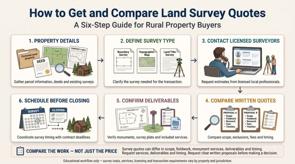
Two proposals may differ in scope, deliverables, schedule, and the amount of work included.
Compare these questions
| Question | Why it matters |
|---|---|
| Is the surveyor properly licensed? | Surveying is regulated by state licensing requirements. |
| What survey type is proposed? | Different surveys serve different purposes. |
| Are boundary monuments included? | The scope of monument work may affect usefulness and cost. |
| Will I receive a signed survey plat? | Buyers may need professional documentation. |
| Are records research and fieldwork included? | Some proposals may exclude additional services. |
| What is the expected completion time? | Scheduling may affect the purchase contract. |
| How are unexpected conditions handled? | Difficult records or missing evidence may change the scope. |
| Can the survey be coordinated with the title company? | This may help address transaction-specific questions. |
Request clarification before accepting a proposal with unclear exclusions.
A written quote is particularly important when the property is remote or has unusual boundary conditions.
8. Can You Use an Existing Land Survey?
Sometimes an existing survey provides useful information, but buyers should not assume it remains sufficient for their transaction.
Ask for the complete survey document and examine:
- The survey date.
- The surveyor’s identification and professional certification.
- The property description.
- The boundary information.
- Any noted easements or encroachments.
- Whether the parcel has changed since the survey.
- Whether the lender or title insurer requires updated work.
An older survey may remain valuable evidence even when new fieldwork is needed.
However, physical conditions can change, documents may have been recorded later, and transaction requirements may differ.
A qualified surveyor and relevant title or legal professionals can advise whether additional work is necessary.
9. Why County GIS Maps Are Not a Substitute for a Survey
County GIS websites are useful tools for researching rural properties.
They may display parcel boundaries, tax identification numbers, acreage, roads, aerial imagery, and other geographic information.
But GIS parcel lines are commonly compiled from multiple sources and may not represent surveyed legal boundaries.
The accuracy and limitations depend on the particular county dataset.
What GIS can help you do
- Identify the apparent parcel location.
- Compare property records.
- Examine nearby roads and terrain.
- Locate possible boundary questions.
- Prepare information for a survey quote.
What GIS cannot reliably establish by itself
- The legally established location of every boundary corner.
- Whether a fence follows the actual property line.
- Whether a driveway is legally accessible.
- Whether a structure encroaches across a boundary.
- Whether the advertised acreage is correct.
For a broader discussion, read How to Buy Rural Land in the USA.
10. Can a Land Survey Reveal Encroachments?
Depending on the survey scope and observable conditions, a survey may identify physical features that appear to cross or conflict with property boundaries.
Examples may include:
- Fences.
- Buildings.
- Sheds.
- Driveways.
- Retaining walls.
- Other visible improvements.
An apparent encroachment does not automatically determine the legal rights of the parties involved.
Questions involving ownership, adverse possession, easements, or boundary disputes may require legal analysis.
If the survey identifies a potential conflict, discuss the issue with the surveyor, title company, and a qualified real estate attorney before closing.
11. Does a Land Survey Confirm Legal Road Access?
Not by itself.
A survey may show roads, driveways, boundary lines, and recorded easements within the agreed scope.
However, the physical existence of a road does not necessarily establish a legal right to use it.
For example, a gravel driveway crossing neighboring land may require a valid recorded easement or another legally recognized access right.
Buyers should investigate both physical access and legal access.
A surveyor can help identify relevant physical and mapped features, while title professionals or attorneys may need to evaluate the underlying legal documents.
Read our detailed guide: Legal Road Access When Buying Rural Land.
12. How Surveys Relate to Easements and Deed Restrictions
Easements can affect where a buyer may place buildings, fences, roads, or other improvements.
A survey may depict certain easements when the relevant documents and scope permit them to be mapped.
However, not every easement is visible on the ground, and not every legal restriction can be determined from a survey.
Deed restrictions may impose requirements that are not apparent from physical measurements.
Review recorded documents alongside survey information.
For further guidance, see:
How to Check Easements Before Buying Rural Land
How to Check Deed Restrictions Before Buying Land
13. Should You Get a Survey Before Building a Cabin?
A survey can be especially useful when the buyer plans to build.
Knowing the property’s boundaries can help with preliminary decisions about:
- Building placement.
- Driveway alignment.
- Required setbacks.
- Utility routes.
- Fences.
- Potential boundary conflicts.
- Access to proposed construction areas.
However, a boundary survey does not automatically determine whether a proposed cabin is permitted.
Zoning, building codes, floodplain requirements, septic approvals, and other local rules may also apply.
Depending on the project, additional topographic or site-specific surveying may be necessary.
Related guide: Can You Build a House on Cheap Rural Land?
14. Who Pays for a Land Survey When Buying Property?
There is no universal rule requiring the buyer or seller to pay for every land survey in the United States.
Responsibility may depend on the purchase agreement, local practice, lender requirements, and negotiations between the parties.
A seller may already have a recent survey.
A buyer may request a new survey as part of due diligence.
A lender or title insurer may also have specific requirements.
Before signing a purchase agreement, ask:
- Is a survey required?
- Who will order it?
- Who will pay?
- What happens if the survey reveals a material issue?
- Can the survey be completed before the relevant contingency deadline?
An attorney or real estate professional familiar with local transactions can help clarify contract provisions.
15. How Long Does a Rural Land Survey Take?
Completion time depends on scheduling, location, property conditions, available records, and the required survey type.
Remote or complex properties may take longer to investigate than straightforward parcels.
Ask the surveyor for an estimated start date and delivery date.
Do not assume that a survey can be completed immediately before closing.
When the survey is important to the purchase decision, coordinate the expected delivery date with the contract’s due diligence period.
A buyer should understand the contractual consequences if the survey cannot be completed on time.
16. Fictional Example: Comparing Two Rural Survey Quotes
Imagine a buyer considering a fictional 35-acre wooded property.
The buyer contacts two licensed surveying firms.
The following example is illustrative only; it does not represent actual market pricing.
| Proposal detail | Surveyor A | Surveyor B |
|---|---|---|
| Survey type | Boundary survey | Boundary survey |
| Records research | Included | Included |
| Fieldwork | Included | Included |
| Monument work | Limited scope | Scope described in detail |
| Signed survey plat | Included | Included |
| Travel expenses | Not clearly stated | Included |
| Unexpected conditions | Additional fees unclear | Written change-order process |
| Completion estimate | Not specified | Estimated schedule provided |
Even without comparing dollar amounts, the second proposal gives the buyer more information about the work and possible additional costs.
That does not automatically make Surveyor B the better choice. The buyer should evaluate licensing, experience, scope, responsiveness, price, and timing together.
17. Land Survey Checklist Before Buying Rural Property
Use this checklist when investigating survey needs and costs.
- Obtain the property’s current deed and legal description.
- Confirm the parcel identification number.
- Ask the seller for previous survey documents.
- Review available county GIS information.
- Identify known boundary or access questions.
- Ask the title company about survey-related requirements.
- Contact appropriately licensed local surveyors.
- Request written quotes for the same scope of work.
- Confirm whether monument work is included.
- Ask about a signed survey plat and other deliverables.
- Check travel charges and possible additional fees.
- Confirm the expected completion schedule.
- Coordinate the survey with purchase contract deadlines.
- Review the completed survey for potential conflicts.
- Seek legal advice about unresolved boundary or easement issues.
- Resolve material concerns before closing.
Frequently Asked Questions
How much does a land survey cost for 20 acres?
There is no reliable universal price based on acreage alone. Location, terrain, boundary complexity, existing records, accessibility, and requested services affect the quote. Contact licensed local surveyors for property-specific estimates.
Is a survey required when buying vacant land?
Not always. Requirements depend on the transaction, lender, title insurer, applicable law, and contract terms. Even when not required, a survey may be valuable due diligence.
Can I find my property lines using GPS on my phone?
A phone GPS application can help with general navigation, but it should not be relied upon to establish legally accurate property boundaries.
Does a survey tell me exactly how many acres I own?
A boundary survey may provide a calculated area based on the boundaries determined and the scope of work. Ask the surveyor how the reported area was established and whether it differs from tax or listing records.
Will a survey show underground utilities?
Not necessarily. Underground utility information may require separate records, locating services, or additional survey scope. Never assume underground utilities have been identified simply because a boundary survey was completed.
Is an ALTA/NSPS survey necessary for a rural cabin purchase?
Usually it is not automatically required simply because the property has a cabin. The appropriate survey depends on the transaction and any lender or title insurance requirements.
Can I reuse the seller’s old survey?
An older survey may be useful, but its acceptability depends on its condition, the transaction, changes to the property, and professional or insurer requirements.
Can a survey resolve a property line dispute?
A survey can provide important professional boundary evidence, but it does not necessarily resolve a legal dispute by itself. Some disagreements require negotiation, legal advice, or court proceedings.
Final Thoughts
Land survey costs are an important part of rural property due diligence, but buyers should focus on more than the quoted fee.
The appropriate survey can help clarify property boundaries, identify physical conflicts, and provide useful information before a buyer commits to a purchase.
Because survey pricing depends on the actual parcel and requested work, written estimates from licensed local professionals are more useful than a generic national average.
Before closing, confirm the survey scope, review the deliverables, and investigate any unresolved boundary, access, or title questions.
Editorial Disclaimer
This article is provided for general educational purposes only. It is not legal, surveying, engineering, financial, or real estate advice.
Survey fees, professional requirements, survey standards, title insurance practices, and property laws vary by jurisdiction and transaction.
Fictional examples in this article are provided only to explain concepts and do not represent actual survey quotes or property transactions.
Before purchasing rural property, consult an appropriately licensed land surveyor and qualified legal, title, or real estate professionals when necessary.
